वापस जायें / Back
Geography of India - Geological Aspects
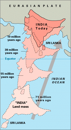
India is located on the Indian plate which is a part of the Indo-Australian plate. It the ancient times it was part of Gondwanaland and was connected with Africa and Antarctica. About 9 crore years back in the cretaceous era it started moving towards north at the rate of 15 cm/year and in the Eocene era it collided with Eurasian plate. Due to this there was a rise in the Tethys depression between the Indian and Eurasian plates which resulted in the creation of the Tibet plateau and Himalaya Mountains by folding. Indian plate is still moving northwards at the rate of approximately 5 cm/year as a result of which the height of Himalayas is increasing by 2 mm/year.
IPeninsular plateau is the oldest land mass in India. It is made mainly of Granite, Nice and Schist rocks. Arawali hills are the oldest fold hills. Eastern and Western Ghats are examples of old residual fold hills.

The hilly region of Himalayas is mainly made of new stratified rocks, which collected in the Tethys Ocean for millions of years. The stratified rocks which were deposited horizontally got extremely folded due to movement of earth and have climbed on one another. Examples of folds, faults, thrust faults and recumbent folding are seen in large areas.
The Indo-gangetic plane is the most recent form geological stand point. The push of the movement of earth from the North at the time of creation of Himalayas resulted in a depression in the northern part of the peninsula and a big valley was formed. The slit from the rivers coming from Himalayas started filling this valley and in this manner over a period of time they created a huge plane. Thus this plane is made mainly from the deposit of alluvium and slit from the erosion of Himalayas. There are layers of sand and soil in it which are of the most recent Pleistocene era.